Weedy seadragon swimming through kelp at The Steps dive site in Kurnell

Kurnell · Kamay Botany Bay National Park

The Steps Kurnell Dive Site

A classic Sydney shore dive for weedy seadragons, kelp-fringed boulders and colourful sponge reef, with routes reaching approximately 18 metres.

Confident Open Water · Shore entry · Typical plan to about 18 m

Kurnell shore diving

Sydney’s iconic weedy seadragon dive

The Steps sits on the southern side of Botany Bay at Kurnell, where kelp, boulders, sand and sponge-covered reef create excellent habitat for temperate marine life. For many local divers, Kurnell diving means slow searches for weedy seadragons here, but patient visitors may also find giant cuttlefish, eastern blue gropers, rays, sharks, nudibranchs and small cryptic species.

This is not one fixed underwater circuit. Divers can explore east or west from the entry, adjust the depth to suit the team, or use The Steps as the exit for the advanced Leap-to-Steps route. Tide, current, swell and visibility decide which option—if any—makes sense on the day.

Quick planning guide

The Steps at a glance

Location
Kamay Botany Bay National Park, Kurnell
Dive style
Out-and-back shore dive, with east and west route options
Typical planned maximum
About 18 m; deeper water exists, so monitor the route and computer
Mapped nearshore terrain
Roughly 5–13 m; reef and wildlife also occur deeper
Experience
Open Water or equivalent, with suitable recent shore-diving experience
Entry and exit
Rock platform below the stairs; inspect before gearing up
Timing
Often planned around slack water or a manageable incoming tide; confirm actual flow locally
Main highlights
Weedy seadragons, kelp, sponge gardens, boulders and macro life

Underwater orientation

Choose east or west—and recognise the exit before you leave it

The following is an orientation guide for qualified divers, not a bearing-by-bearing navigation plan. The route, turnaround and maximum depth must come from the day’s current, the team’s gas plan and a current site briefing.

  1. Inspect the entry and exit from above

    Walk down before gearing up. Watch several sets, identify the usable rock ledge or sheltered groove, and confirm how every diver will enter and leave the water.

  2. Descend on the shallow boulders

    After moving clear of the rock platform, the usual descent is in roughly 4 m of water over boulders. The boulders meet sand around 5–6 m, with kelp lying to either side.

  3. Fix the exit cue in your mind

    Near the entry, a break in the kelp leads back south across the shallow boulders to the exit. Note the depth, shape and compass direction on the way out; do not rely on one visual cue alone.

  4. Select the route that opposes the usable current

    East and west both offer worthwhile out-and-back diving. Choose only after checking the flow and agreeing on a route, maximum depth, gas reserve and contingency with the buddy team. A one-way drift requires a separate incoming-tide plan and inspected exit.

  5. Turn for gas, time and conditions—not a landmark

    Monitor gas, no-decompression time, depth and current throughout the dive. Begin the return early enough to regain the exit comfortably, complete any required safety stop and surface with the planned reserve.

Standardised map of The Steps dive site showing parking, stairs, entry and exit, boulders, reef and depth contours
Planning aid only. This map shows the principal nearshore terrain and approximately 5–13 m contours, not every route or the full deeper profile. Features can change; use a current local briefing, compass and your own observations.

East from the entry

Kelp, seadragon habitat and deeper sponge reef

The eastern route crosses kelp before opening onto boulders and sponge-covered reef. The mapped nearshore terrain spans about 5–13 m, while reef and wildlife continue deeper and a longer route can approach 16–18 m. Depth is an outcome of the plan, not a target.

West from the entry

Boulders, sponge growth and optional swim-throughs

To the west, kelp gives way to boulders between the shallow wall and sand. The reef becomes more defined towards Sutherland Point and, farther west, the Monument, with several optional swim-throughs. A one-way Steps-to-Sutherland Point drift is specifically an incoming-tide plan requiring local knowledge, an inspected exit and organised shore logistics.

Return cue

Use the kelp break, shallow boulder line and compass together

Near The Steps, the gap in the kelp and the wall of boulders around 5 m help orient divers towards shore. Confirm the exit positively before committing to the final approach; reduced visibility, current and surge can make familiar terrain look different.

Entry, exit and access

Inspect the whole route to the water before gearing up

From the car park to the platform

The Steps car park is reached along the main Kurnell park road. An opening in the fence leads down rough-hewn steps, past the viewing area and onto a narrow stair-and-bridge section above the rock platform. Move carefully, keep the access clear and take particular care when the path is wet.

Choose a controlled entry for the actual water level

The small rock basin and eastern ledge can provide access when conditions suit. The appropriate technique changes with tide height, surge and the diver’s mobility. Confirm the water is deep and clear, keep the buddy team ready, and use the controlled entry described in the current briefing—never follow a fixed technique simply because it worked on another day.

Plan the exit before entering

The entry area also serves as the normal exit. Identify the most protected usable approach, keep mask and regulator in place, time the final movement with the water and remain in control until securely clear. If the water is washing heavily across the rock or the exit cannot be used confidently, change the dive plan.

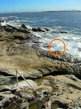
View down the stairs towards the rock entry and exit area at The Steps
View from the stairs towards the water-access area.
Side view of the rock platform and stair access at The Steps in Kurnell
Side view of the platform; conditions determine the usable route.

Important: These photographs are for orientation only. Rock shape, water level, wash and access conditions seen on your dive day take precedence.

Temperate marine life

Slow down—the best sightings are easy to swim past

The Steps rewards patient observation more than distance. Search the kelp edges, sponge growth, sand and sheltered sides of boulders without touching or disturbing the habitat. All animals are wild, seasonal and unguaranteed.

Weedy seadragons, seahorses and pipehorses

Weedy seadragons can blend almost perfectly with kelp and drifting weed. Seahorses and tiny pipehorses may be found around sponge growth by divers with sharp eyes and careful buoyancy. Learn how weedies differ from their relatives in our weedy, leafy and ruby seadragon comparison.

Giant cuttlefish and eastern blue gropers

Large boulders and ledges provide shelter for giant cuttlefish, while eastern blue gropers may cruise the reef. Give both animals room and allow them to choose the encounter.

Port Jackson sharks, wobbegongs and rays

Port Jackson sharks appear seasonally, wobbegongs may rest beneath ledges and several ray species can move across the sand. Never crowd a resting animal or block its route.

Nudibranchs and sponge-garden specialists

Colourful nudibranchs, sponge crabs, moray eels, morwong, wrasse, goatfish, gurnards and velvetfish add variety for divers who look closely rather than rushing along the reef.

For a wildlife-focused outing, check the Sydney dive calendar for seadragon-focused dives. Maintain neutral buoyancy, keep fins and gauges clear, and never touch, chase, feed or reposition an animal for a photograph.

Match the dive to the diver

Is The Steps right for your next dive?

A good match

Current and comfortable in ocean entries

You hold at least Open Water or equivalent certification, have recent shore-diving experience, can manage mild current and surge, and can navigate an agreed out-and-back route with your buddy.

Get local guidance

Your first Kurnell dive

A local guide or experienced site buddy can show the water-access options, exit cues, kelp line and current behaviour that are difficult to learn from a map alone.

Choose another site

The flow, wash or confidence is wrong

Change the plan if the entry or exit is being washed, the current is stronger than expected, visibility undermines navigation, or any diver is rusty or uncomfortable.

Conditions and safety

Tide timing helps—but it never replaces an on-site decision

When The Steps can work well

  • The platform and exit are calm enough for the whole team.
  • The current is light, understood and compatible with the planned route.
  • Slack water or a manageable incoming tide supports the chosen timing.
  • Visibility allows reliable natural and compass navigation.
  • The route, depth and gas plan suit every diver’s certification and recent experience.

When to change the plan

  • Breaking water, surge or wash makes the entry or exit doubtful.
  • The current is already difficult to hold against near the entry.
  • The team cannot confidently recognise or regain the exit.
  • Any diver is over-weighted, low on recent experience or uncomfortable with the access.
  • Park alerts, closures or on-site signs restrict access.

The Steps is relatively sheltered from southerly to south-easterly swell but more exposed to northerly through east-south-easterly swell. No single swell-height rule guarantees a safe dive: direction, period, tide height, wind, surge and local wrap all matter. Inspect the site, use current local advice and keep a more sheltered backup option.

Before entering

A practical Steps safety check

Agree on route, depth and turn pressure

Decide east or west, maximum depth, minimum return gas and exit approach before entering. Do not wait until gas is low to choose a shallow route home.

Use a visible dive flag and signalling equipment

Boat traffic can pass through the wider area. Carry an appropriate visible dive flag or float and surface-signalling equipment, and follow current NSW waterway rules.

Confirm buddy and lost-buddy procedures

Review team positioning, communication, separation procedure and the response to an unplanned ascent. Maintain close contact when visibility or current reduces.

Protect feet, hands and exposure

Use sturdy dive boots and suitable exposure protection for uneven, abrasive rock and local water temperature. Move slowly on wet stairs and the platform.

Make swim-throughs optional

Bypass every overhead unless training, buoyancy, visibility, surge, gas and a clearly visible exit make it appropriate for the complete buddy team.

Leave the habitat as you found it

Secure gauges and alternate air sources, avoid kneeling or finning into kelp and sponges, and never handle marine life—even for identification or photography.

Important: This page provides general orientation, not training or a live site briefing. Each diver remains responsible for current conditions, certification limits, equipment, gas, navigation and the decision to enter.

Location and park access

Getting to The Steps at Kurnell

Allow for national-park access

The Steps is inside the Kurnell area of Kamay Botany Bay National Park. Gate hours, vehicle fees, construction impacts, parking availability and temporary closures can change, so check the official visitor information and local alerts before travelling.

Keep the access usable for everyone

Set up without blocking the fence opening, path, stairs or bridge. Carry equipment carefully on the narrow descent, follow on-site signs and take all rubbish and loose gear away when you leave.

Frequently asked questions

The Steps dive site FAQs

How deep is The Steps?

A typical planned maximum is about 18 metres, while deeper water exists depending on the route. The site map depicts nearshore terrain from roughly 5–13 metres, but wildlife and sponge reef also occur deeper. Treat depth as part of the planned profile rather than a target and stay within certification, experience and computer limits.

What certification and experience do I need?

Open Water or an equivalent certification can cover suitable Steps routes, but certification alone does not establish readiness. Divers also need recent experience, stable buoyancy, buddy skills, current awareness and confidence with a rocky shore entry. Event-specific requirements may be higher.

What tide is best for The Steps?

The Steps is often planned around slack water or a manageable incoming tide, with the outward leg opposing a controllable current. Actual water movement can differ from a published tide time, so confirm conditions at the site and do not enter if the flow is beyond the team.

Will I see a weedy seadragon?

The Steps is one of Sydney’s best-known weedy seadragon habitats, especially around the kelp and adjacent reef, but no sighting can be guaranteed. Move slowly, maintain excellent buoyancy and never chase or reposition an animal.

Should I dive east or west?

Both directions offer kelp, boulders, sponge growth and marine life. The eastern route is commonly chosen for seadragon habitat and deeper sponge reef; the western route develops towards boulders and optional swim-throughs. Current, conditions and the team’s plan should decide.

Is The Steps the exit for The Leap?

Yes. The advanced one-way dive from The Leap normally finishes at The Steps and is planned for manageable incoming water. It is different from an ordinary Steps out-and-back dive and requires suitable certification, experience, depth and gas planning, plus inspection of both access points.

Should I use a guide on my first visit?

Local guidance is strongly recommended for a first Kurnell dive. The entry, exit cue, current, kelp line and route choices are far easier to understand after a site-specific briefing in the day’s actual conditions.

Explore Kurnell with local support

Make The Steps part of your Sydney diving

Join a scheduled guided shore dive, arrange a private guide for a wildlife-focused visit, or compare The Steps with other Sydney sites before choosing the right dive for the conditions.

Top